Duror & KentallenNews
< back to News page
Pre Application Consultation Open for Proposed Communications Site at Coille Dhubh, Auchindarroch Road, Glen Duror
Here is the communication from Mitie:
SHARED RURAL NETWORK - EE – TOTAL NOT SPOT (TNS) PROGRAMME
PRE APPLICATION COMMUNITY CONSULTATION
PROPOSED COMMUNICATIONS SITE REF: EE TNS HUB1076 / 85721 ON LAND AT COILLE DHUBH, AUCHINDARROCH ROAD, GLEN DUROR PA38 4BT, NGR: 202401, 753225
EE Is one of the UK’s four mobile network operators (along with Three, Vodafone and O2) working on the Total Not Spot Programme (TNS) part of the wider Shared Rural Network Scheme (SRN). Mitie are appointed as the Acquisition & Planning agents working on behalf of EE on the Total Not Spot (TNS) programme in this area. As you may be aware, the Shared Rural Network (SRN) is a telecommunications programme which sees the UK Government working in partnership with the four UK mobile network operators - EE, O2, Three and Vodafone - to increase mobile connectivity in rural parts of the UK.
Mobile connectivity has become an integral part of society with extensive economic and social benefits however, it is recognised that the lack of mobile communications coverage in remote and rural areas intensifies the digital divide and can hinder rural development. The Shared Rural Network will deliver 4G coverage to 95% of the UK, offering significant improvements to mobile coverage for rural communities, businesses and visitors. These improvements cannot be delivered without the building of new infrastructure. The TNS Programme involves the construction of new infrastructure in areas where there is currently no 4G coverage from any mobile operator. Every new site on the TNS Programme will be available to all the mobile operators to share including the new emergency services network (ESN), thereby providing essential connectivity across all operators.
Please find enclosed the following documents which make up our formal pre application consultation:
- Description of Development
- Site Location Plan
- Site Photos
- Details of alternative options considered and discounted.
- Site Plan
- Site Elevation Drawing
Description of Development
Proposed installation of a 25m high lattice mast (Galvanised steel finish) accommodating 3No antennas; 3No 0.6m transmission dishes and ancillary development within a compound surrounded by a timber posted deer fence and gabion walls. The proposed compound will also accommodate; 6No equipment cabinets; 1No electrical meter cabinet; 1No Off-Grid backup Power Generator with integrated fuel tank and ancillary development. The proposed communications equipment will be powered by off-grid renewable energy comprising 1No 15m high wind turbine and an array of 42 solar panels within a separate fenced compound. The proposed communications compound will be accessed directly off the existing stone forestry track and a 48m long section of new compacted stone track will be installed to provide vehicular access to the solar panel compound.
OS Map of Proposed Site Location

Site Photos

.png)

Search Area Plan
Prior to instructing Mitie on this project, EE carried out a detailed review and assessment of the 83 Total Not Spot (TNS) sites assigned to them by the UK Government to deliver. EE’s review resulted in the ability to meet the necessary TNS coverage requirements in the assigned areas using just 62 sites rather than the original 83 sites allocated to them. The consequential reduction of 21 new greenfield mast requirements from sensitive and rural Scottish environments is a very significant achievement in minimising the overall impact of the SRN network on the character, visual amenity and environment of rural Scotland, while also delivering the necessary improvements to mobile coverage for rural communities, businesses and visitors.
Due to the very remote nature of these site requirements, they will rely on having clear Line of Sight (LOS) to link back to the national mobile communications network using transmission dishes on the mast. On that basis, the full list of site requirements was split up into different groups of sites (Clusters) which would link into each other using LOS transmission dishes before then connecting into the existing national network via LOS transmission links to an existing and established communications site. Where operationally and physically feasible, proposed new site locations have been microsited to avoid the most exposed locations and most sensitive designations, while also aiming to use existing and established access tracks for construction and maintenance purposes.
EE TNS Cluster 74
- EE TNS Cluster 74 aims to provide high quality 4G coverage to Total Not Spot areas in Salachan Glen and Glen Duror;
- Cluster 74 is made up of 1No existing communications site and 3No proposed new communications site as detailed below:
- EE Ref: 85721 - Land at Coille Dhubh – NGR: 202401, 753225 (subject of this enquiry)
- EE Ref: 85675 – Land at Salachan Glen - NGR: 199207, 751538 (subject of a separate pre app enquiry)
- EE Ref: T16529 – Keil Track – NGR: 197374, 752854 (will be subject of a future pre app enquiry)
- Existing Communications site on Ardsheal Hill – NGR: 199561, 756755

- The Total Not Spot coverage area for Cluster 74 includes commercial forestry and an extensive network of tracks and paths which are popular with walkers, hikers and cyclists.
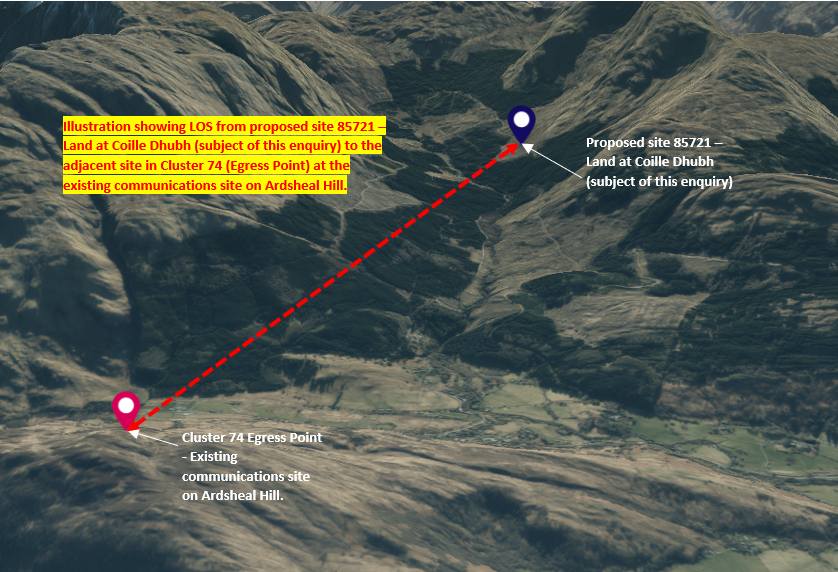
- The image below shows the LOS (facing north west) from the proposed site subject of this enquiry at 85721 - Land at Coille Dhubh to the next site in the network at the existing communications site (Egress Point & connection into the national communications network) on Ardsheal Hill. Without clear LOS between the proposed communications site and the existing communications site on Ardsheal Hill, this Cluster would not be operationally feasible.

- The image below shows the LOS between the proposed site subject of this enquiry at 85721 - Land at Coille Dhubh to the next site in the network at the existing communications site (Egress Point & connection into the national communications network) on Ardsheal Hill. Without clear LOS between these sites, this Cluster would not be operationally feasible. This image also helps to illustrate the highly effective visual screening and backdropping that will be provided to the proposed mast by the rising land at the eastern extent of Glen Duror:
Proposed Site Requirements
Before progressing with the site subject of this pre application enquiry, Mitie undertook a search of the area around the nominal location to establish possible site options that would meet the following requirements:
- Within LOS visibility of the Egress point (to ensure connectivity into the wider national communications network).
- Accessible by vehicle (using existing access tracks wherever possible in order to minimise harm to environmental and visual amenity).
- Locations which would provide an appropriate level and location of TNS coverage uplift.
- Locations that minimise impact on environmental and visual amenity.
- Sites that avoid impact on the functions and operations of the underlying landuse.
Reasons for Site Selection
The proposed site location for 85721 is adjacent to an existing forestry track in a large area of commercial forestry outwith any sensitive land designations. As detailed below, the original nominal location assigned by the UK Government for EE to deliver was located in an area of steep sloping terrain, remote from any existing access tracks. Further investigation of the surrounding area found a way to deliver the required level of TNS pixel uplift via a rearrangement of Cluster 74 to sites that are closer to existing and established access tracks, thereby significantly reducing impact on the environment and visual amenity of the area. The proposed mast and ancillary development at this proposed site location will benefit from the visual backdropping provided by the rising hillside to the North, South and East of Glen Duror.
EE have confirmed that the proposed mast height of 25m at this location is the minimum height possible to provide the necessary level of TNS pixel coverage uplift along this section of Glen Duror while also providing clear LOS to the adjacent site in the Cluster to the North West. Alternative options in the area that were considered and discounted are detailed in the list below:
D1: Land at Coille Dhubh, (nominal location) NGR 202750, 752650
This location was the original Nominal location assigned by the UK Government for EE to deliver. Following an investigation of the proposed site location it was discounted due to its location on steeply sloping terrain with no existing access track nearby. A review of the surrounding area found that alternative options existed which would have less impact on the environment, character and amenity of the area by avoiding the need for long sections of new access tracks to be constructed.
D2: DMSL Site 314 near Beinn a’ Bheithir NGR: 204563, 754448
This location was the original Nominal assigned for EE to deliver as the next site along Cluster 74 from the site subject of this enquiry (85721). While this location benefits from the ability to use existing forestry access tracks, it would not provide clear LOS to the existing communications site on Ardsheal Hill and would require an additional intermediate communications site to link this area into the existing national communications network. Further investigation of the area found that installing proposed communications site 85721, at the location described in this letter, would provide the necessary TNS coverage uplift in Glen Duror, while also providing LOS visibility to the Egress point on Ardsheal Hill. This adjustment of the site locations forming part of Cluster 74 mean that the TNS coverage requirements in Glen Duror can be met by the single site (subject of this pre application enquiry) rather than two sites.
D3: Glen Duror Track West NGR: 202232, 753253
An option at this location was considered to be a reasonable option from a planning perspective due its location in a non-designated commercial forestry and adjacent to an existing and established access track thereby helping to minimise visual impact on the surrounding area when compared to a site requiring a new access track. This option was discounted in favour of a location further east that would provide better coverage along both sections of the Glen Duror ‘elbow’ to the north west and north east.
The proposed site location for 85721 is considered to be the preferred option in the area in terms of providing the required level of coverage uplift to the Total Not Spot (TNS) area along Glen Duror, while also providing the necessary Line of Sight (LOS) visibility to the next site in Cluster 74. The proposed site location is directly adjacent to an existing vehicular access track, thereby negating the significant visual and environmental impact associated with installing new access tracks in rural areas. The proposed 25m mast will benefit from being viewed in the context of the rising land to the north south and east of Glen Duror.
Overall, it is considered that the public benefit of providing high quality 4G communications coverage to the TNS area in Glen Duror will outweigh any minor visual impacts resulting from the proposed installation.
The proposed location subject of this letter has been identified following rigorous Cluster and site investigations and allows for the programme to meet coverage obligations as set by Ofcom, the programme regulator while also minimising impact on the character and amenity of the area.
We would be grateful for any feedback or comments you may have (preferably within 14 days of this email) on the proposal detailed in this email before we proceed to a formal planning application. We would also appreciate your feedback on any interested parties or stakeholders that you think we should consult on this proposal.
Thank you in anticipation for your help as the Programme proceeds and please do not hesitate to contact us if you need any further information in the meantime.
Kind Regards,
Ginny
Ginny Hall MRTPI | Acquisition and Planning Manager | Technical Services
Mitie | 35 Duchess Road, Rutherglen, Glasgow, G73 1AU
Mobile: 07385 974 799
Files included in the original email:

Community COUNCIL
D & K Community Council: meetings, minutes, councillors and more...
Community Council page>
Community CENTRE
The Community Centre is at the heart of the local community. Hall events, hire the hall and more...
Community Centre page>